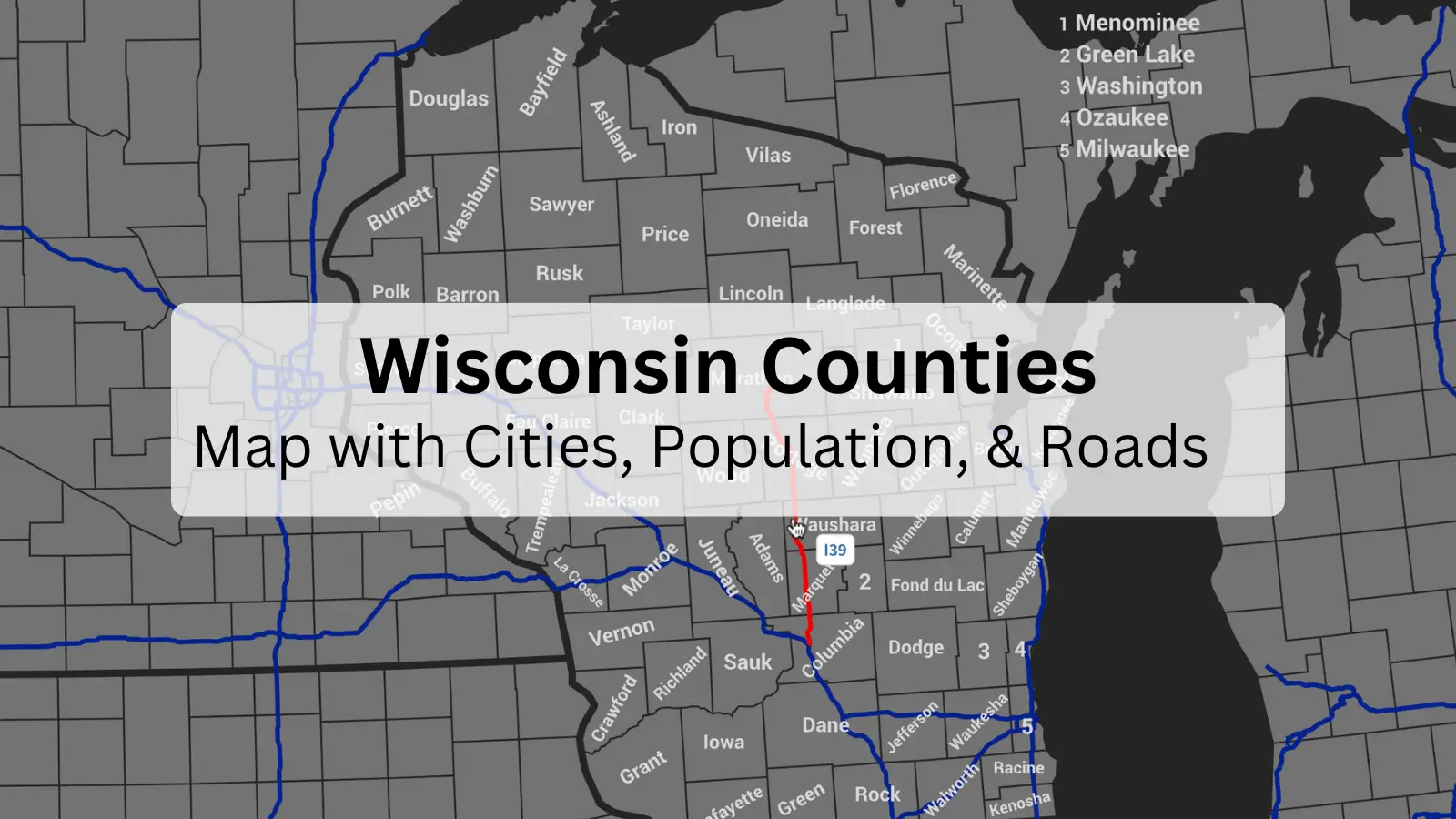
Wisconsin Counties: Map with Cities, Population, & Roads
Wisconsin is better known as the Dairy State because it has more dairy farms than any other state in the United States. Located in the Midwest and surrounded by the Great Lakes, Lake Superior to the North and Lake Michigan to the East. Wisconsin is also nicknamed the Badger State after its rich history of mining. Miners were nicknamed badgers because they dug tunnels and lived in them, just like badgers
If you’re thinking about moving to Wisconsin, hiring reputable Wisconsin movers is a must. Muberr is a Wisconsin Moving Company ready to help your transition to Wisconsin as smoothly as possible. Not only will we take care of all the heavy lifting, but our team will also help guide you to the perfect Wisconsin city that’s right for you. We can even help you choose the best neighborhood. Give us a call at 920-662-4863 or book your move online.

Plan your next move with Muberr.
Table of Contents
ToggleWisconsin counties map
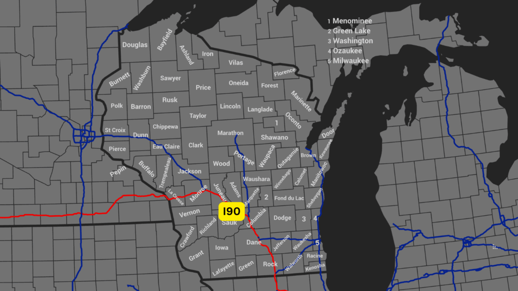
Wisconsin is made up of 72 counties. Here is a map of all 72!
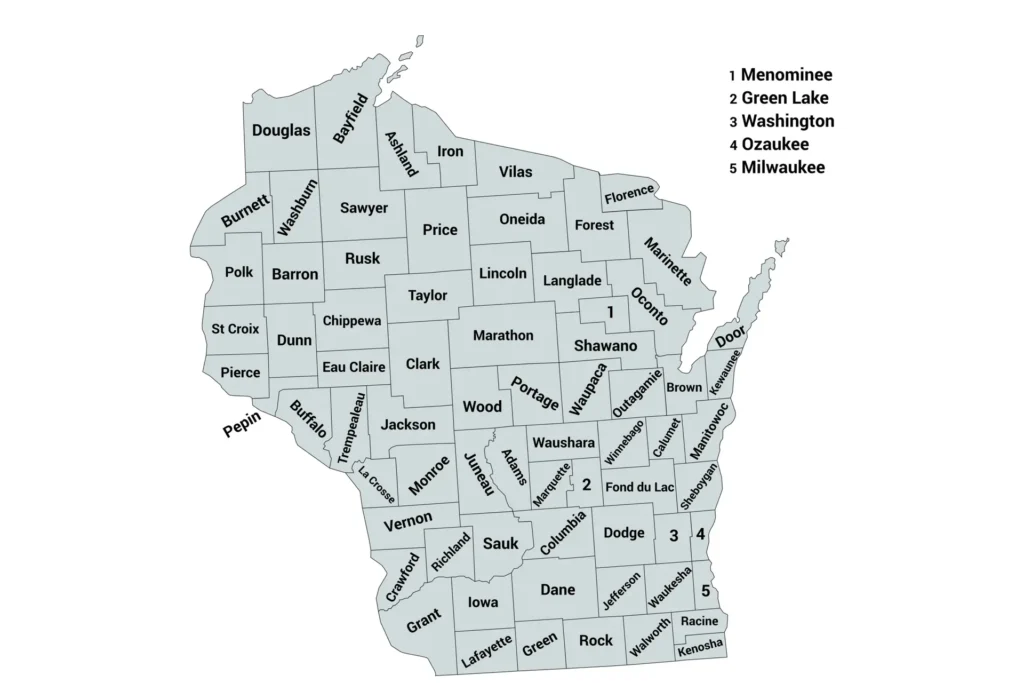
Wisconsin counties map with cities
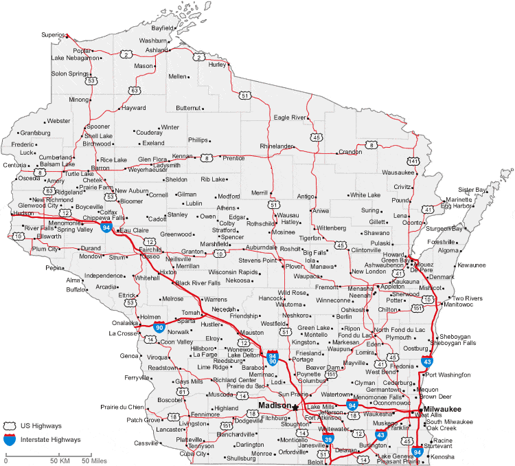
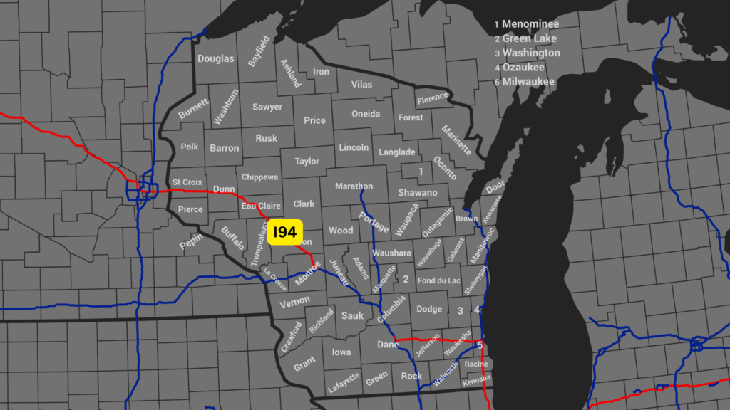
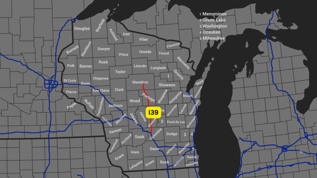
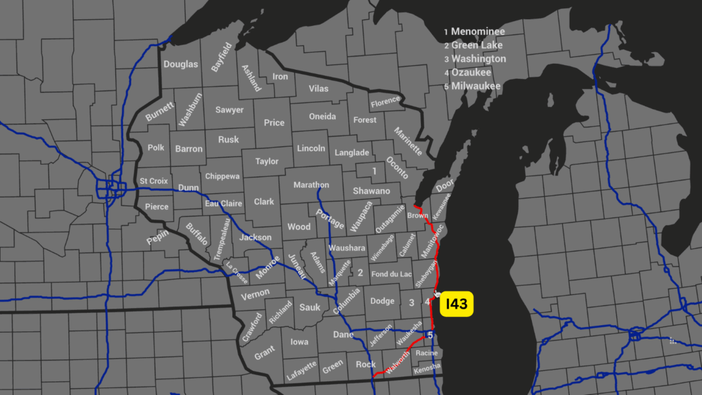
Wisconsin counties map with highways
Highway I90
Highway I94
Highway I39
Highway I43
Wisconsin county map PDF
Get the county map PDF here
How many Wisconsin counties?
In Wisconsin, there are a total of 72 counties
Counties by population
| Rank | County | Population |
|---|---|---|
| 1 | Milwaukee | 918,661 |
| 2 | Dane | 573,254 |
| 3 | Waukesha | 413,145 |
| 4 | Brown | 271,408 |
| 5 | Racine | 197,727 |
| 6 | Outagamie | 194,407 |
| 7 | Winnebago | 172,331 |
| 8 | Kenosha | 169,151 |
| 9 | Rock | 164,020 |
| 10 | Washington | 138,424 |
| 11 | Marathon | 135,692 |
| 12 | La Crosse | 120,617 |
| 13 | Sheboygan | 118,434 |
| 14 | Walworth | 106,970 |
| 15 | Eau Claire | 106,239 |
| 16 | Fond du Lac | 104,837 |
| 17 | St. Croix | 95,430 |
| 18 | Ozaukee | 91,029 |
| 19 | Dodge | 89,320 |
| 20 | Jefferson | 87,136 |
| 21 | Manitowoc | 81,320 |
| 22 | Wood | 74,410 |
| 23 | Portage | 70,747 |
| 24 | Chippewa | 66,297 |
| 25 | Sauk | 66,278 |
| 26 | Columbia | 58,722 |
| 27 | Calumet | 55,633 |
| 28 | Grant | 52,038 |
| 29 | Waupaca | 50,195 |
| 30 | Barron | 47,990 |
| 31 | Monroe | 46,274 |
| 32 | Polk | 45,125 |
| 33 | Dunn | 45,040 |
| 34 | Douglas | 44,295 |
| 35 | Pierce | 43,889 |
| 36 | Shawano | 40,786 |
| 37 | Marinette | 40,397 |
| 38 | Oconto | 39,361 |
| 39 | Oneida | 38,086 |
| 40 | Green | 37,404 |
| 41 | Clark | 34,659 |
| 42 | Trempealeau | 30,760 |
| 43 | Vernon | 30,714 |
| 44 | Door | 30,066 |
| 45 | Lincoln | 28,415 |
| 46 | Juneau | 26,822 |
| 47 | Waushara | 24,420 |
| 48 | Iowa | 23,686 |
| 49 | Vilas | 23,016 |
| 50 | Jackson | 21,117 |
| 51 | Adams | 20,654 |
| 52 | Taylor | 20,245 |
| 53 | Langlade | 19,491 |
| 54 | Green Lake | 18,896 |
| 55 | Sawyer | 18,074 |
| 56 | Richland | 17,219 |
| 57 | Lafayette | 16,665 |
| 58 | Burnett | 16,526 |
| 59 | Crawford | 16,157 |
| 60 | Washburn | 15,865 |
| 61 | Marquette | 15,593 |
| 62 | Ashland | 15,450 |
| 63 | Bayfield | 15,159 |
| 64 | Rusk | 14,188 |
| 65 | Buffalo | 13,366 |
| 66 | Price | 13,052 |
| 67 | Forest | 8,991 |
| 68 | Pepin | 7,318 |
| 69 | Iron | 6,035 |
| 70 | Florence | 4,558 |
| 71 | Menominee | 4,255 |
| 72 | Florence | 4,558 |
Counties by area`
| Rank | County | Area (sq mi) |
|---|---|---|
| 1 | Marathon | 1,576 |
| 2 | Bayfield | 1,477 |
| 3 | Marinette | 1,401 |
| 4 | Sawyer | 1,350 |
| 5 | Douglas | 1,310 |
| 6 | Price | 1,254 |
| 7 | Clark | 1,216 |
| 8 | Dane | 1,201 |
| 9 | Grant | 1,183 |
| 10 | Oneida | 1,113 |
| 11 | Vilas | 1,018 |
| 12 | Forest | 1,014 |
| 13 | Chippewa | 1,010 |
| 14 | Oconto | 998 |
| 15 | Jackson | 991 |
| 16 | Taylor | 975 |
| 17 | Rusk | 931 |
| 18 | Barron | 890 |
| 19 | Shawano | 893 |
| 20 | Burnett | 880 |
| 21 | Lincoln | 879 |
| 22 | Dodge | 876 |
| 23 | Langlade | 873 |
| 24 | Dunn | 850 |
| 25 | Washburn | 853 |
| 26 | Sauk | 837 |
| 27 | Wood | 809 |
| 28 | Portage | 801 |
| 29 | Vernon | 792 |
| 30 | Trempealeau | 742 |
| 31 | Waupaca | 748 |
| 32 | Waupaca | 746 |
| 33 | Iron | 758 |
| 34 | Columbia | 766 |
| 35 | Iowa | 768 |
| 36 | Juneau | 767 |
| 37 | Buffalo | 681 |
| 38 | Waushara | 637 |
| 39 | Lafayette | 634 |
| 40 | Green | 584 |
| 41 | Waukesha | 581 |
| 42 | Winnebago | 579 |
| 43 | Pierce | 576 |
| 44 | Walworth | 576 |
| 45 | Outagamie | 638 |
| 46 | Eau Claire | 638 |
| 47 | Green Lake | 380 |
| 48 | Menominee | 365 |
| 49 | Kewaunee | 343 |
| 50 | Calumet | 319 |
| 51 | Milwaukee | 241 |
| 52 | Ozaukee | 233 |
| 53 | Pepin | 232 |
| 54 | Kenosha | 272 |
| 55 | Racine | 333 |
| 56 | Jefferson | 557 |
| 57 | Rock | 721 |
| 58 | Sheboygan | 515 |
| 59 | Manitowoc | 589 |
| 60 | Brown | 530 |
| 61 | Door | 482 |
| 62 | Florence | 488 |
| 63 | La Crosse | 480 |
| 64 | Marquette | 464 |
| 65 | Washington | 436 |
| 66 | Ashland | 1045 |
| 67 | Menominee | 357 |
| 68 | Fond du Lac | 722 |
| 69 | Monroe | 908 |
| 70 | Crawford | 571 |
| 71 | Richland | 586 |
| 72 | Adams | 645 |
FAQ
What are the different counties in Wisconsin?
The different counties are:
| County Name |
|---|
| Adams |
| Ashland |
| Barron |
| Bayfield |
| Brown |
| Buffalo |
| Burnett |
| Calumet |
| Chippewa |
| Clark |
| Columbia |
| Crawford |
| Dane |
| Dodge |
| Door |
| Douglas |
| Dunn |
| Eau Claire |
| Florence |
| Fond du Lac |
| Forest |
| Grant |
| Green |
| Green Lake |
| Iowa |
| Iron |
| Jackson |
| Jefferson |
| Juneau |
| Kenosha |
| Kewaunee |
| La Crosse |
| Lafayette |
| Langlade |
| Lincoln |
| Manitowoc |
| Marathon |
| Marinette |
| Marquette |
| Menominee |
| Milwaukee |
| Monroe |
| Oconto |
| Oneida |
| Outagamie |
| Ozaukee |
| Pepin |
| Pierce |
| Polk |
| Portage |
| Price |
| Racine |
| Richland |
| Rock |
| Rusk |
| St. Croix |
| Sauk |
| Sawyer |
| Shawano |
| Sheboygan |
| Taylor |
| Trempealeau |
| Vernon |
| Vilas |
| Walworth |
| Washburn |
| Washington |
| Waukesha |
| Waupaca |
| Waushara |
| Winnebago |
| Wood |
What is the biggest county in Wisconsin?
The biggest county by area is Marathon County. The biggest county by population is Milwaukee County.
Where can I get a Wisconsin Map?
You can get a Wisconsin County Map here.
How many counties are in Milwaukee, Wisconsin?
There are a total of 72 counties in Wisconsin.
